

Map Reading Skills - An Introduction
A beginners guide to map reading skills
If you’ve decided it’s time to #GetOutside and explore, a good map is going to be your best friend. At Dennis Maps we print some wonderful maps, including the much-loved Ordnance Survey series covering the UK. Some basic map reading skills will help you to plan your adventures and stay on track when you’re out and about.
A map is a representation of the ground as seen from above, drawn to scale and including symbols that show features of the landscape and built environment. Please click on the images for an expanded view.
OS Explorer maps - the orange Ordnance Survey (OS) Explorer maps are on a 1:25,000 scale, which means that one unit on the map represents 25,000 units on the ground. 4 cm on the map shows 1 kilometre, which allows for a lot of detail. Explorer maps are therefore ideal for walking and exploring.
OS Landranger maps - these are pink and have a scale of 1: 50,000, which means 1 kilometre on the ground is shown by only 2 cm on the map. So they are useful when you are covering more ground, in a car or on a road cycle.

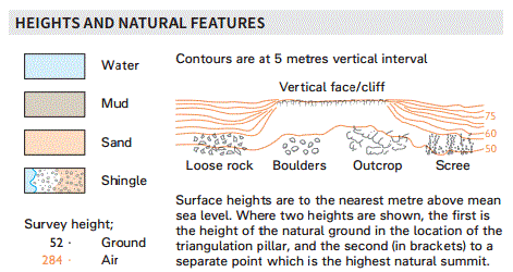
Symbols - map symbols often look exactly like what they represent - a beer mug for a pub, or a blue ‘P’ for parking, for example. Every map has a legend or key at the side that explains in detail the different kinds of buildings, paths, roads, woodlands and boundaries.
Contour lines - the thin, wavy brown lines are contour lines that show the shape and height of the landscape - and do not appear on the ground! The map key tells you whether the contour lines are 5 or 10 metres apart. A shallow slope is depicted by contour lines that are far apart. When the lines are close together, there is a steep slope. Look along the lines and you will spot brown numbers that show the height of the ground above sea level.
With a little practice of your map reading skills you will be able to look at a 2D map and get a fair idea of what the landscape looks like in 3D, which is helpful in planning your outdoor exploration. The distance you aim to cover may not be long but it will still be arduous if the terrain is rugged.
Grid references - OS maps are criss-crossed with thin blue lines making up a grid. Each square on the grid is numbered from left to right and from bottom to top. The horizontal squares run from west to east and are called eastings. The vertical squares are numbered from south to north and are called northings.
These numbers are used to create grid references that identify a place on the map. Find your grid reference by running along the eastings at the bottom of the map until you find the number to the left of the square you’re in, and then up the northings on the side to the number at the bottom of that square. These two numbers, written in this order, provide your 4 figure grid reference.
On the orange Explorer maps you will see that the squares are further divided into tenths along the edges of the map. You can precisely pinpoint a location such as a building with a 6 figure grid reference. To do this you look at the square and estimate how many tenths the location lies along the line. Then how many tenths from the bottom. Add these numbers to your grid reference after the easting and northing.
In addition to using your map reading skills on the paper folded maps you can also access Explorer and Landranger maps on your mobile, tablet and desktop. Aerial imagery provides a 3D view and brings the map to life, and an Augmented Reality feature labels interesting places within the landscape to help you explore.
A 7 day free trial is available at https://osmaps.ordnancesurvey.co.uk/52.48621,-2.21548,7
You might also like:
Further information on map symbols.
Planning a walk with an OS Map.
Dennis Maps is one of the leading map printers in the world, producing more than two million maps and charts every year. We offer comprehensive pre-press services, large format posters using both large format litho printing and large format digital print technologies, plus specialised map folding and map finishing techniques.

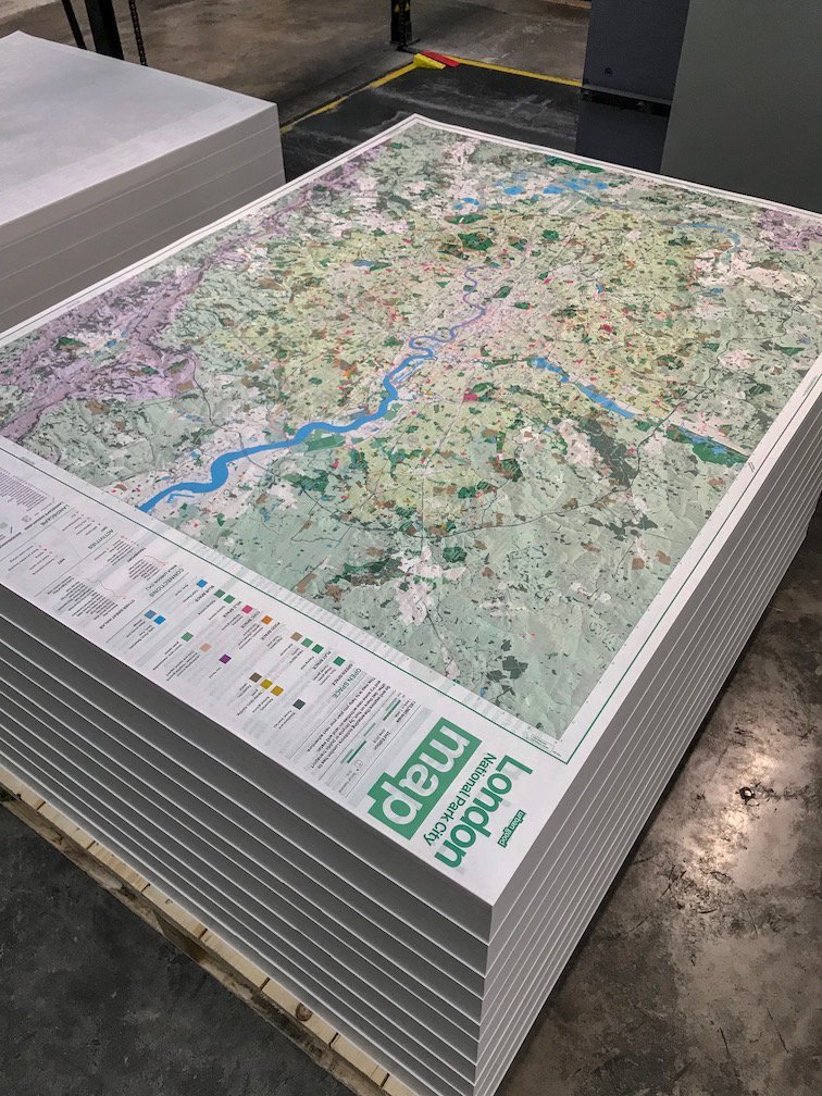
London National Park City Map
Hot off the press - the new London National Park City map
We love our work here at Dennis Maps and we’re very proud of one of our recent achievements, the printing of the new London National Park City map. It’s a large-format, folded map, printed on the best stock on the same press as the Ordnance Survey Explorer maps, using bright Pantone inks.
Social enterprise Urban Good, which works to improve the urban environment, raised money for the project through crowdfunding. They collaborated with Ordnance Survey and Greenspace Information for Greater London to create a beautiful map that would inspire Londoners to get out and enjoy their natural surroundings.
You may have seen the map on BBC Countryfile’s special Cities episode, which featured Woodberry Wetlands, a wildlife haven just a stone’s throw from the tower blocks of Stoke Newington.
If your impression of London is that it’s a concrete jungle packed with buildings and roads, thronged with people and congested with traffic, you’ll be surprised to learn that 49.5% of London is estimated to be green and blue space! That includes public parks and woodland, playing fields, front and back gardens, reservoirs, rivers, canals and ponds.
As we pointed out in our #GetOutside post, you don’t have to drive miles to the countryside to have an adventure outdoors. The London National Park City map reveals the urban landscape, showing where you can walk, sail and play many kinds of sports.
 You’ll see at once that this isn’t anything like the London maps you’re used to looking at, as the focus is not on the streets and the famous landmarks. What is immediately striking is the sheer amount of green.
You’ll quickly get your eye in, and start to spot the many walks and outside activities highlighted in fluorescent orange. Then you’ll notice the familiar circular symbols for tube and railway stations, and you will easily be able to plan the start and end of your adventure near public transport.
Turn over the London National Park City map, and on the reverse you’ll find a giant atlas of London packed with fascinating facts about its parkland, woodland, rivers, hills and foxes (there may now be as many as 10,000 of these creatures living in the city).
Plus twenty ideas for exploring London you may never have thought of or even knew were possible in the city - come face-to-face with a goat at a city farm, for example, pitch your tent at a campsite, or go white-water rafting on the River Lea!
In 2019 London will become the world’s first National Park City, taking inspiration from the UK’s rural National Parks, where natural beauty and wildlife are protected. A National City Park is a large urban area that is managed in order to enhance its living landscape and provide a better quality of life.
 The aim is for London to become greener, with more natural wild spaces, and reduced flood risk due to more planting. Also healthier, with better air quality, and with more experiences available outdoors, which will connect communities and improve standards of everyday life.
Revitalising the way the city relates to its natural environment is at the heart of creating the National Park City. Developers, clubs, community groups and individuals will be encouraged to join in with the ‘micro-greening’ of London, by creating living roofs, quiet green spaces and ‘greening’ their front gardens.
Thousands of copies of the London National Park City map have already been distributed. To get your own copy for just £4 (with free shipping in the UK) and find out how much green and blue surrounds your neighbourhood, visit the Urban Good website.
And you can keep up-to-date with the latest news and share the photos of your explorations of London’s great outdoors on social media by using the hashtag #NationalParkCity.
Take a look at our Urban Nature Amsterdam Map post or, for a historical view of London, see our post on a Medieval Map of London.
Dennis Maps is one of the leading map printers in the world, producing more than two million maps and charts every year. We offer comprehensive pre-press services, large format posters using both large format litho printing and large format digital print technologies, plus specialised map folding and map finishing techniques.

The Heart of England Forest
Why Dennis Maps supports The Heart of England Forest Project
A fact you may not realise about Dennis Maps is that we are jointly owned by the Estate of Felix Dennis, operating for the benefit of the Heart of England Forest Registered Charity, and Ordnance Survey, Britain’s mapping agency.
The Heart of England Forest is therefore a project very close to our hearts here at Dennis Maps. It was created by Felix Dennis, the self-made owner of Dennis Publishing, who began his colourful career selling copies of the underground magazine Oz on London’s Kings Road.
A natural entrepreneur, he pioneered computer and hobbyist magazine publishing in the UK, including the bestselling titles Maxim and The Week. He owned land in Warwickshire, and wanted to bring native broadleaf trees back to the local landscape and create woodland the public could enjoy, as well as provide an environment for wildlife.
Felix Dennis planted the first small wood near his home in Dorsington, Warwickshire, in 1996. His vision was to plant at least 300 acres each year to create a joined-up woodland. The forest is mainly in South Warwickshire and stretches from the ancient Forest of Arden in Warwickshire to the edge of the Vale of Evesham.
As a poet himself, Dennis no doubt appreciated that The Forest of Arden is the setting for Shakespeare’s comedy As You Like It, and in Elizabethan times covered a vast area that included the sites of modern-day Birmingham and Coventry.
The Heart of England Forest Registered Charity was set up in 2003. During 2019/20 136,977 trees were planted, a total of 1,883,928 since the charity began.
The majority of trees are English oak and ash, and also include birch, cherry, hornbeam, sweet chestnut and rowan. They are planted in a random pattern in woodland blocks separated by wide rides during the planting season of mid November to March.
 The charity now manages more than 3600 acres, including both ancient woodland and new areas for planting. There are already two easy walking trails of 1.5 and 3.5 miles that have been mapped out by the Head Forester through new broadleaf forest.
There are plans for off-road bike trails, woodland play areas and camping and a cafe and arts centre. A programme of events runs throughout the summer, including open days at The Garden of Heroes and Villains, a private sculpture garden commissioned by Felix Dennis at Dorsington. Over 50 bronze sculptures are set in grounds that also contain a yew hedge maze, poetry garden and woodland walks.
All funds raised from the sale of tickets to events supports the work of the charity in planting trees, creating wildlife habitats, and woodland education.
There are many ways you can get involved in the project. As a Friend of the Heart of England Forest, making a monthly donation from as little as £3, as a business providing team-building experiences for your staff, as a teacher bringing pupils on a school visit, or as a hands-on volunteer
 To give you some idea how much your donation helps, just £5 pays for enough seed to plant a 100m square wild flower meadow in the forest. £60 buys 40 tree coils and stakes that provide protection from rabbit and deer damage and support saplings as they grow into beautiful mature trees.
A visit to the Heart of England Forest is the perfect opportunity to #GetOutside and enjoy all the benefits of spending time in the natural world, breathing fresh air, and taking gentle exercise.
And a step back in time to an age when Britain was still covered in native broadleaf forest. Please visit the Heart of England Forest website for more information about visiting and ways to participate.
Dennis Maps is one of the leading map printers in the world, producing more than two million maps and charts every year. We offer comprehensive pre-press services, large format posters using both large format litho printing and large format digital print technologies, plus specialised map folding and map finishing techniques.

#GetOutside: do more in the British Outdoors
What's the #GetOutside hash tag all about?
 One of our major clients here at Dennis Maps is Ordnance Survey, whose maps have been guiding us around the British countryside for generations. Now the Ordnance Survey campaign #GetOutside is encouraging more of us to get out into the open air and take off for an adventure.
The physical and mental health benefits of being outside in nature are indisputable. Research by the University of Michigan revealed that it helps us to relax, increases attention span and improves memory. Stanford University found it reduces stress and symptoms of depression.
A study in Sweden discovered that hospital patients who could see trees from their window needed less medication and had much better recovery rates.
In Japan doctors prescribe ‘shinrin-yoku’ or forest bathing to patients. It’s been scientifically proved that spending time sitting and walking in the forest has many health benefits, including reducing blood pressure and blood-sugar levels, boosting the immune system, increasing energy and reducing anxiety and anger.
We all instinctively know we feel better for a spell outside in nature, but how do you change habits and start to make time outdoors a regular feature of your life?

The Beginner’s Guides on the Ordnance Survey website provide lots of ideas on where to go and what to do. Don’t worry if you’ve never done anything like this before, there are guides to help you learn to use a compass, understand map contour lines and map scales, read grid references and much more.
Plus there’s a huge range of suggestions for what to do in the great outdoors, from walking, cycling and climbing, to water sports and camping. Did you know that Dartmoor is the only place in England where you are legally allowed to wild camp?
There are 15 National Parks in Britain, from the rugged Cairngorms in Scotland to Exmoor in South West England, the beautiful Pembrokeshire coast in South Wales to the Norfolk Broads. They were designated back in the early 1950s to preserve their natural beauty and provide recreational opportunities for the public.
But don’t worry, you don’t have to drive for miles from an urban area to the countryside. The new OS Greenspace map layer is a new way to discover green spaces right on your doorstep.
Available in both the web and app versions of OS Maps, it shows you where to find parks, playing fields, allotments, and other publicly accessible places where you can reconnect with nature.
In every region of Britain #GetOutside Champions, experienced adventurers from the worlds of sport, TV and journalism, are offering their own advice on getting out and about. Ben Fogle, for example, who is well-known for his adventures here and abroad, including rowing the Atlantic, and presents TV programmes about the countryside.
 You might think only the able-bodied can participate in #GetOutside. Think again! Mel Nicholls is an endurance wheelchair racer and paracyclist, and is currently training for the Tokyo Olympics in 2020. She also enjoys sports like sea swimming and climbing, and wants to encourage anyone with a disability barrier to become active outside.
If you’re stuck for where to start there are plenty of ideas on the Adventures page, with routes graded according to difficulty with detailed directions and photos so you can see the terrain you’ll cover, in both town and country.
You can also find suggestions for activities suitable for all the family, places to visit and special events to attend. And don’t forget to follow #GetOutside on Instagram and Twitter to keep up-to-date with all the latest news and share your own tips and experiences.
Forest photo by Ahmad Kadhim on Unsplash
Compass photo by Daniil Silantev on Unsplash
Wheelchair photo by Ariel Pilotto on Unsplash
Dennis Maps is one of the leading map printers in the world, producing more than two million maps and charts every year. Print large size. We offer comprehensive pre-press services, large format posters using both large format litho printing and large format digital print technologies, plus specialised map folding and map finishing techniques.

Behind the Scenes at Dennis Maps
An interview with Steve Burry MD of Dennis Maps Ltd
 Dennis Maps Ltd is the largest map printer in the UK, producing more than 2.3million maps and charts each year from our facility in Frome, Somerset.
Steve Burry has been involved in printing all his working life, since starting his career in book printing at the age of 18. He’s been involved in map printing since 2010 and Managing Director of Dennis Maps Ltd since 2014. Here he describes the day-to day activity at the site:
What does a typical day look like at Dennis Maps, or is every day different?
We employ 28 people involved in various functions from admin to manufacturing.
Our highly skilled workforce have expertise in pre-press reproduction and design, printing (both traditional litho and digital) together with map finishing.
Map printing is a very specialised sector of printing, with very different requirements and expectations. For example, in terms of printing it is almost a case of ‘less is more’, where accuracy and clarity of extremely fine detail is more important than vibrant high intensity of colour and visual impact.
A typical day for Dennis Maps Ltd in terms of operations is very structured and follows a repeating and rhythmic pattern compared with the experience of many printers.
This is because the majority of our business is contractually based. So we know what demand will be and that we’ll have a certain amount of business every day, week, month and year.
This means that the factory operates to a constant beat, with several weekly orders in various stages of production at any one time. So we have a fairly continuous production flow, albeit punctuated between the individual orders.
What are the highlights in the calendar?
 The business is perhaps surprisingly seasonal, with production levels rising through the first quarter of the year before reaching a peak from April through to September. I’m never happier than when we are in the midst of that production cycle!
Demand can reduce a bit in October, which allows us to draw breathe and prepare for the onslaught of the Christmas demand for the online Custom Made product that we produce for Ordnance Survey.
A monthly highlight is when we receive the monthly Key Performance Indicator (KPI) report from our largest contractual customer. Every aspect of our performance is analysed and measured against a set of extremely demanding KPIs. It’s always very satisfying to see that we are able to achieve and maintain such high standards of quality and service without deviation.
What’s the best part of the job?
My job is immensely satisfying, whether it’s maintaining the high levels of service to our existing clients, or meeting a new client and securing a first order from them. This always feels like a true moment of someone putting their trust in us.
I enjoy seeing those new orders being produced, and take a real pleasure in looking at the intricacies of the different styles of cartographic design. Some of the maps that we print are almost works of art in their own right.
Of course, I also feel immensely proud to be leading this company and continuing the heritage of large format printing in Frome that stretches back 170 years.
What does the future hold, and what would be your dream achievement for Dennis Maps?
The future of printed maps is a very interesting question, with rumours of their death so far having been greatly exaggerated!
Undoubtedly the growth of digital delivery systems has reduced the demand for the printed product. But this does now seem to have stabilised and even increased slightly over the last few years.
Perhaps analogue paper and digital delivery have found a means of peaceful co-existence, at least for now. Nonetheless I do feel that demand pattern will change, as will the method by which the printed maps are produced and brought to market.
I personally believe that we will see an evolution towards a more on-demand, highly customised and digitally printed map product gather pace rapidly over the next few years. I intend for Dennis Maps to be at the forefront of that!