

Eggnogg – a colourful kind of business
There’s something unique about Bertha the Caravan – you can colour her in! She’s one of many whimsical creations dreamed up by Kate Edmunds for her business Eggnogg. The company’s speciality is colour-in products for kids (and adults, too). Its weird and wonderful creations are jam packed with black and white illustrations, just waiting to be filled with colour.
The Bristol business is known for its iconic tablecloths – which are printed by Dennis Maps. Eggnogg sells around 40 fabric and paper colouring-in products, ranging from tablecloths to colour-in cards and even Christmas trees. Then there’s Bertha, who can be rented out as a quirky addition to events. We catch up with designer and illustrator Kate to find out more about Bertha, and her other fun-filled creations.

Kate, your idea for Eggnogg started in Italy. Tell us a bit more about this.
My family and I were in Anghiari, Italy, eating at our favourite pizzeria. Fernando, our waiter, popped down the usual paper tablecloth with a pot of pens. Unfortunately, it was so full of advertising my children struggled to find enough white space for their creations. This gave me an idea – why not create a tablecloth full of black and white illustrations for children to colour in? Eureka! Our colour-in tablecloth was born.
What were your first products and who did you sell them to?
Our first products were colour-in postcard books which were sold in Hobbycraft, Liberty and WHSmith. It was a dream come true to have them sell our products. All our hard work had finally paid off.
What’s your favourite product from the Eggnogg range and why?
I love the seaside poster / tablecloth. It reminds me of long summer holidays.
How do you come up with your designs and product ideas?
Originally, Eggnogg’s products were inspired by my young children, Mathilda and George. I conjured up useful product ideas that would keep them busy, creative – and quiet! I’m also inspired by picture books from my childhood, like ones by author and illustrator Richard Scarry. I love Tim Burton’s work, too. I take a sketch book everywhere so I can design wherever I am.
How did Bertha the Eggnogg Colour-in Caravan come to be?
We created Bertha a few years ago. I always loved the idea of having a colour-in caravan, so I searched eBay and found a rather dilapidated but adorable little caravan. We spent two weeks renovating her, both inside and out. We had a deadline as we were going to appear on Dragons’ Den. She’s starred on ITV’s This Morning with Holly and Phil, too. They loved her.


What’s the best part of running your business?
I’ve always wanted to be an artist, so I love doing the creative parts of Eggnogg and coming up with new products.
Any exciting plans for Eggnogg you’re able to reveal?
The future of Eggnogg is looking bright considering these tricky circumstances. Plenty of new product ideas are always on the cards, although they’re top secret right now. Watch this space!
Dennis Maps is one of the leading map printers in the world, producing more than two million maps and charts every year. We offer comprehensive pre-press services, large format print solutions using both large format litho printing and large format digital print technologies, plus specialised map folding and map finishing techniques.

‘There’s something deep within us that’s brought to life when we forage’
Foraging
James Wood knows this more than most. One of the UK’s top foraging experts, he’s the founder of Totally Wild UK, author of The Foragers’ Cookbook and has lent his expertise to BBC Countryfile and ITV’s Countrywide. He speaks to us about his passion for wild food, and his top tips for foraging through the seasons.
James, what makes foraging so special?
There’s something deep within us that’s brought to life when we forage. We’re connecting with our natural surroundings in a practical and meaningful way. Historically, we’ve been foraging for longer than we’ve been farming. And who doesn’t like to find some fantastic ingredients for free?

Can you tell us about your best foraging experience?
I remember heading out with a friend to look for morel mushrooms. In a whole day we found nothing. When we’d nearly given up, we found a single one growing out of the sand dunes. I can remember them cheering behind the sand dune in complete joy.
Tell us a bit about Totally Wild UK. What inspired you to launch the business?
My ultimate goal was to bring foraging in to the 21st century and have it recognised in a more serious way. Totally Wild has grown into a team of professional foragers who’ve all achieved a foraging and wild food accreditation, which we developed ourselves. We hold foraging courses. We’ve even started offering a Wild Veg Box scheme, with ingredients curated by our foragers.
Do you forage for different ingredients as the seasons change?
We really move with the seasons. Throughout spring the hedgerows are full of delightful salads and blossoms. In summer we head to the coast for seaweeds and salty marshland plants. Come autumn we’re off to the woods to hunt for mushrooms. Autumn really is the time for berries and mushrooms. The easiest mushroom family to start on are the boletus species. There’s a section on our website for identifying them.
Do you have any favourite autumn recipes that use foraged foods?
I’ve got a lovely recipe for mushroom ketchup and I also enjoy this bilberry pie recipe, that I started out making for my Grandma
On your website you mention that foragers can make paper from foraged mushrooms. What other unusual items can be made from foraged foods?
It depends how experimental you want to get and how much time you have on your hands! You can make glue from seaweeds, ink from the bark of oak trees, and a sweet jelly from a mushroom called jelly ears. You can even make plasters from birch polypores.
What top tips would you give to beginner foragers?
Only pick a little from each plant – less than 20% of what’s there – and only take what you’re actually going to use. Other than that, always start with the things that are easy to identify and easy to find. And start with one new species at a time. If you have a stew using 10 new ingredients and you get ill, it’s much harder to know which ingredient caused it.
I’d always advise starting with stinging nettles. They’re everywhere and we all know what they are. Try as many recipes as you can with them. For example, nettles can be used in smoothies, wilted like spinach, fried into crisps, dried and powdered as a matcha alternative, boiled into a cordial… it goes on and on.

What resources and tools should beginner foragers start with?
When it comes to tools, invest in some secateurs and a small, sharp knife. At Totally Wild, we all use hooked folding knives for our picking. And of course, you’ll need a basket because what’s a forager without a basket?
I’d also recommend An Initial Guide to the Identification of Mushrooms & Toadstools, it was my go-to guide for starting to learn about mushrooms. I’d suggest getting a recipe book to give you ideas for cooking with what you find, too. It’s great finding foraged ingredients, but we need ideas for cooking with them, as well!
Dennis Maps is one of the leading map printers in the world, producing more than two million maps and charts every year. We offer comprehensive pre-press services, large format print solutions using both large format litho printing and large format digital print technologies, plus specialised map folding and map finishing techniques.
The UK’s most weird and wonderful buildings
Weird & Wonderful Buildings
With World Architecture Day falling this month, it’s the perfect time to visit some of the UK’s weird and wonderful buildings. From the Shark House to the Pineapple, there are loads of architectural oddities to explore, whether on a day trip or even an overnight stay.
The Shark House, Oxford, England

At first glance, it appears to be a normal house in a row of Oxford terraces. But look up and you’ll see a 25-foot shark crashing through the roof. Former owner Bill Heine commissioned sculptor John Buckley to create the one-off fibreglass sculpture. It caused quite a stir when it appeared in the 1980s – without planning permission – and Oxford City Council worked to have it removed. Over the years, it’s become an accepted, if unusual, feature of the street. You can even stay in the Shark House, for a holiday with a difference. Check it out on Airbnb.
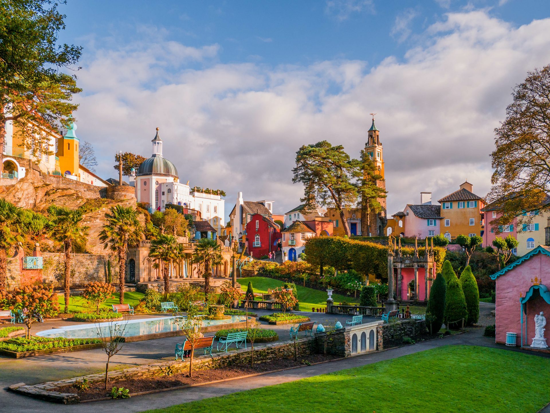
Portmeirion, Minffordd, Wales
You’d be forgiven for thinking you’d stumbled upon an Italian village when you visit Portmeirion. It’s a magical jumble of colourful buildings, set among lush woodland and dramatic cliffs. Dreamed up by Welsh architect Sir Clough Williams-Ellis, it took over 50 years to perfect. He designed Portmeirion as an Italian village and included an eclectic array of architecture. It boasts plenty to keep tourists entertained, including sandy beaches, a piazza and a gelateria. It’s easy to see why it’s attracted so many notable visitors over the years, from author H. G. Wells to the Beatles’ George Harrison. A visit to Portmeirion will transport you to Italy without even stepping on a plane.

This pineapple-shaped property was commissioned by the 4th Earl of Dunmore as a summerhouse, from which to enjoy views over his vast estate. In the 18th century, pineapples were exotic fruits in Scotland, so it was a display of social standing to have one to eat, let alone one to relax in. The Earl was also the Governor of Virginia, a colony where sailors often added pineapples to their gateposts to mark their return from sea. This custom likely influenced him to build his fruity folly after returning from Virginia. Walkhighlands has a walking route that passes by the Pineapple and through the Dunmore Estate. You can book a holiday in the Pineapple too.
The Leadenhall Building (the Cheesegrater), London, England
The Leadenhall Building stands out among neighbouring skyscrapers for one reason – it looks remarkably like a cheesegrater. Its unusual shape was dreamed up by architects Rogers Stirk Harbour + Partners, adding a touch more quirkiness to London’s eclectic skyline. The building is supported by a steel frame and stretches a dizzying 224 metres into the sky. It was designed with a slanted glass front, so as not to obscure views of nearby St Paul’s Cathedral. Admire the award-winning building from the outside or visit its ground floor plaza for a different perspective.
The Smallest House in Great Britain, Conwy, Wales
The Smallest House in Great Britain, or ‘Smalls’, can be found along Conwy’s quayside. You’ll soon spot the bright red building, despite it being a miniscule 122 inches high, 72 inches wide and 120 inches deep. This teeny-tiny building only has two cramped rooms and 1.5 metres squared of utilisable floor space. The Guinness World Record holder has a bed and bookshelves but no space for a toilet. This didn’t put tenants off though, with several people calling it home. Its most recent tenant, Robert Jones, even stood at a statuesque 6-foot 3 inches tall! Smalls hasn’t been lived in since 1900 and is now open to the public. Why not visit The Smallest House as part of a Conwy walk? There’s a lovely route of around two miles, that takes in Smalls, the River Conwy and the town walls.
The Royal Liver Building, Liverpool, England

The Royal Liver Building has been a much-loved Liverpool landmark for over 100 years. It’s often claimed to be the first skyscraper in Europe, and it certainly looks like it’s straight out of a US city. According to The Guide Liverpool, it even represented a Washington DC building in an episode of The Crown. It also features two mythical Liver Birds, each perched on one of its clock towers. One bird looks out over the city (to protect it) and the other over the River Mersey (to guide boats into port). Find out more on a tour of the Royal Liver Building.
Plan your architectural adventure with an Ordnance Survey map
Dennis Maps is one of the leading map printers in the world, producing more than two million maps and charts every year. We offer comprehensive pre-press services, large format print solutions using both large format litho printing and large format digital print technologies, plus specialised map folding and map finishing techniques.

Awaken your senses on an autumn walk
Walks take on a different sensory experience as seasons come and go. Autumn brings its own sights, sounds, smells, textures and even tastes, that are unique to the season. There’s so much to delight in, from crunchy autumn leaves to delicious hedgerow fruit. Take your next walk at a slower pace and really savour the season.
Autumn Walks
All the colours of autumn
It’s the time of year when leaves turn glorious autumnal shades and flutter free from deciduous trees. Look out for them swirling in the autumn breeze or creating a stunning carpet on the ground – perfect for crunching! You only need to step out your door to see an attractive array of golden colours. But for the most impressive spectacle, go for a walk at an arboretum. These botanical gardens are planted with large tree collections and offer an impressive palette of autumn hues. There are many to explore in the UK, including Westonbirt, The National Arboretum, “a magical tree garden”.

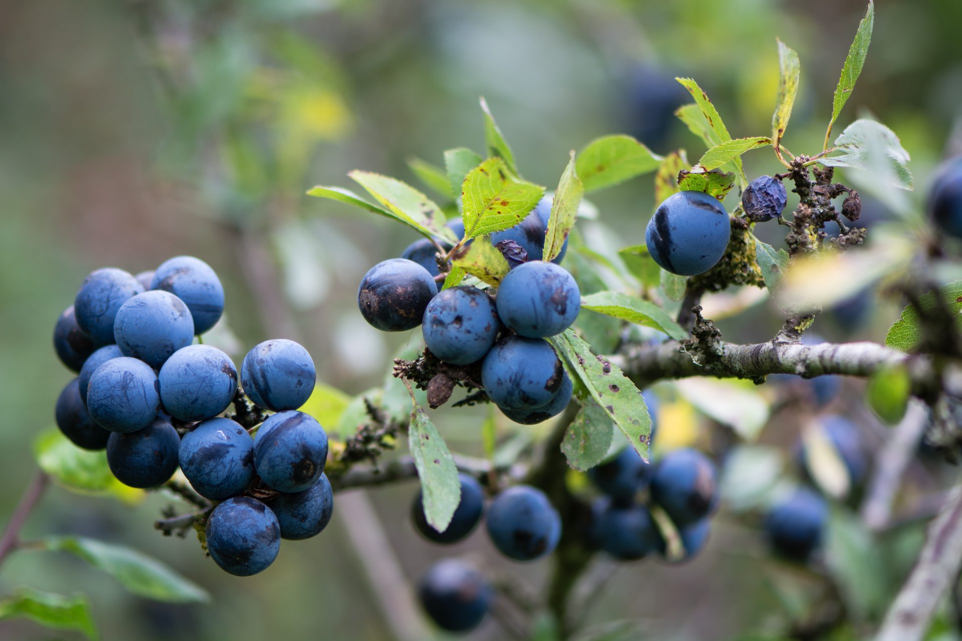
Take it sloe
An autumn walk is the perfect opportunity for foraging in hedgerows. Look out for sloes, an inky-purple fruit that grow on blackthorn trees. Sloes are a relative of the plum and an excellent fruit to pick if you’re a first-time forager. You’ll know they’re ripe when they’re a beautiful dark shade, plump and squash slightly when squeezed. Remember to forage them responsibly and sustainably. The Woodland Trust has a useful guide for this. It’s best not to eat sloes raw – when they taste bitter – but they’re delicious once cooked. Hugh Fearnley-Whittingstall has a tasty recipe for crab apple and sloe sorbet, or you could go for a traditional tipple. Check out Jamie Oliver’s recipe for sloe gin.
Wonder at autumn wildlife
There’s plenty of wildlife to marvel at on a walk, even as winter draws closer. Look out for small wonders – autumn’s golden light catching on spider webs, or squirrels collecting their nuts. On a larger scale, autumn is deer rutting season. It’s incredible to see stags lock antlers in competition for females – but don’t forget to watch from a safe distance. Countryfile has listed the best places to witness this autumn spectacle. It’s also the season to spot incoming migrant birds. You might come across redwings, pink-footed geese, and starlings who’ve migrated from the continent. An early evening stroll can reveal one of nature’s greatest spectacles – a murmuration swooping gracefully across the sky. Wonder at these groups of starlings forming spectacular, ever-changing shapes in the fading light. Somerset’s Avalon Marshes is a great place to see them in action.

Seasonal treasures
Nothing says autumn quite like horse chestnut trees laden with conkers. We’re in the middle of conker season, so you’ll find many scattered on the ground beneath these majestic trees. Why not search for these shiny brown seeds with little ones? Once you’ve collected them, you can use this popular method to harden them. Then they’re ready to use for conker contests (threaded with pieces of string) or to keep as autumn treasures that’ll last for years. You can even use conkers to make laundry detergent, for an eco-friendly touch.

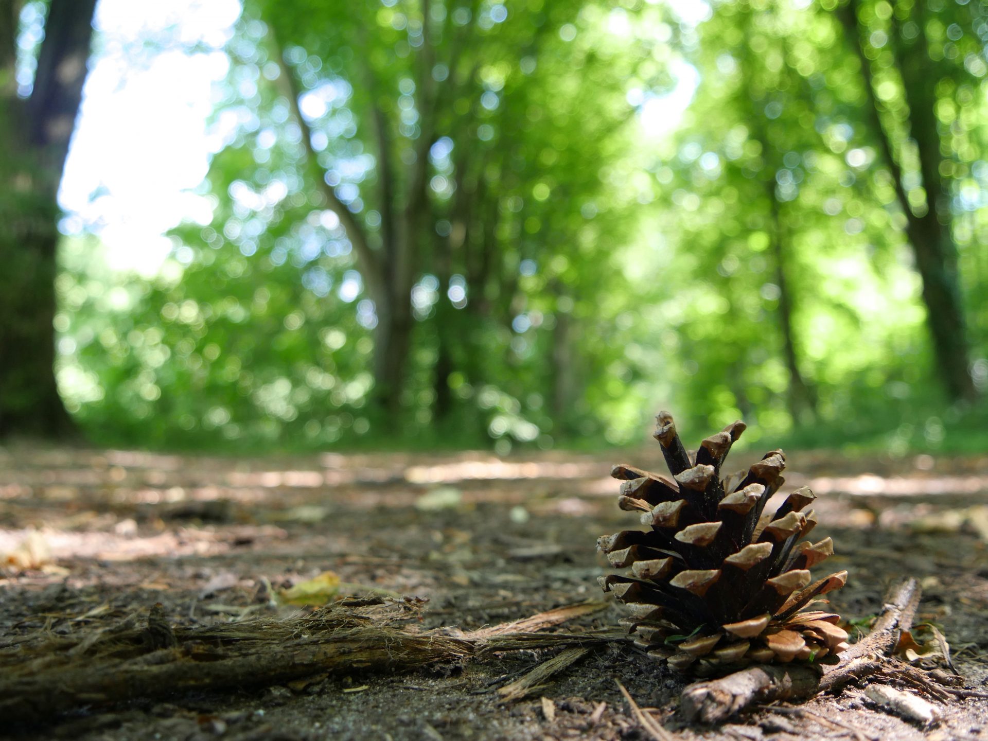
The scent of the season
There’s something special about the scent of pine trees. You’ll notice their refreshing aroma long before you spot them. It’s a scent that evokes the outdoors and awakens the senses. During autumn they drop their precious cones, scattering them across the woodland floor – ready for collecting. Why not take a handful home with you? They hold the lingering scent of pine, transporting you to an autumnal wood or forest, even when you’re indoors. They make attractive DIY décor, as well. Silver or gold spray paint turns them into sparkling decorations, with silver pinecones thought to bring good luck, too.
Plan your autumn walk with an Ordnance Survey map
Read Plan a Walk with an OS Map
Dennis Maps is one of the leading map printers in the world, producing more than two million maps and charts every year. We offer comprehensive pre-press services, large format print solutions using both large format litho printing and large format digital print technologies, plus specialised map folding and map finishing techniques.

Will you join the Great British Beach Clean?
The Great British Beach Clean is coming to a beach near you and you’re invited to take part! The Marine Conservation Society (MCS) is calling for volunteers to join its annual event, to clean up the UK coast. “As the world starts to open up again, the Great British Beach Clean is a fantastic opportunity to get out and do something good for the environment,” says comedian Zoe Lyons, MCS’s newest Ocean Ambassador.

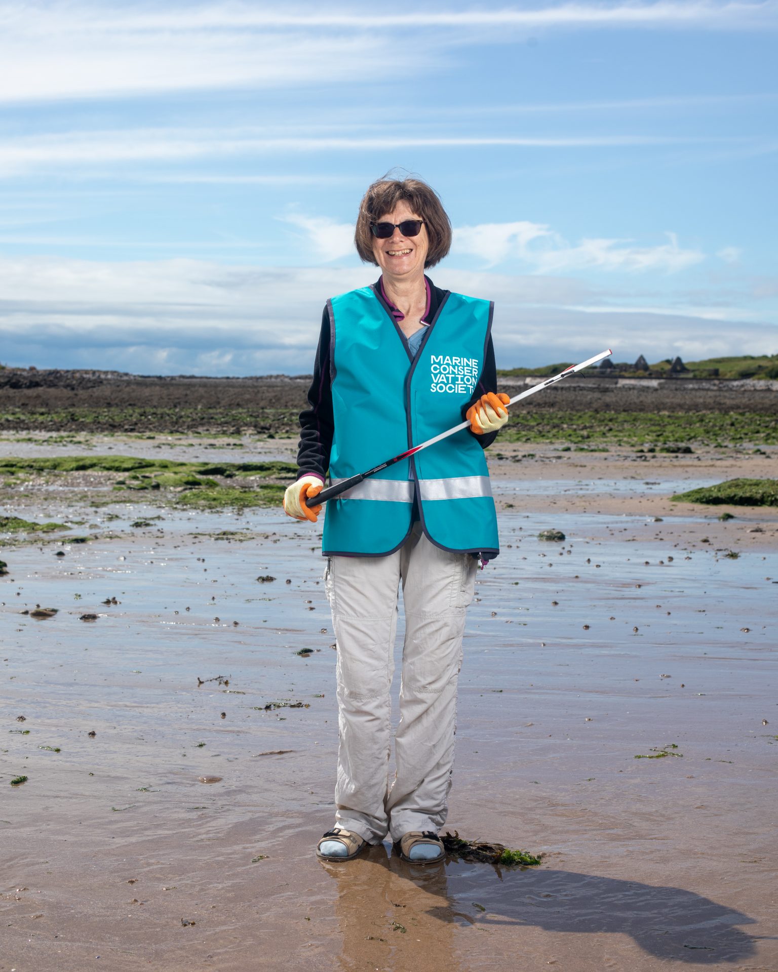

Between Friday 17th and Sunday 26th September, volunteers will pick up litter to keep our beaches beautiful and protect marine life. Shockingly, around 11 million tonnes of plastic enters the ocean each year. By getting involved, you can help stop this flow of litter. The event is much more than just a beach clean, though. Every year, volunteers log the litter they collect on each 100-metre stretch of beach, and share their findings with MCS experts. The data is then used to campaign for change. Previously, data has helped introduce plastic bag charges. And it’s currently proving helpful in a campaign for a deposit return scheme for drinks containers in the UK. So why not be part of a sea change and get involved?
“We’re hoping that more volunteers than ever before are beach clean ready this year,” says Lizzie Prior, Beachwatch Officer at the MCS. “Come rain, shine or gale force winds, we’ll be there with a litter picker in hand with a smile on our faces,” adds Zoe. There are beach cleans taking place across the UK, no matter where you are. The MCS website has details of your nearest beach clean. If you want, you can even organise your own! You could make a day of it and explore the area around the beach after your litter pick, too.

Of course, much of the litter on beaches and in the sea begins its journey far from the coast, in villages, towns and cities. That’s why the charity is holding its Source to Sea Litter Quest, as part of the Great British Beach Clean. It’s a fantastic way to help all year round, by stopping pollution before it even reaches the sea. Just download a form from the MCS website, get your gloves on and step outside for your litter pick.
Thousands of volunteers have joined the Great British Beach Clean over almost three decades. Will you be one of them this year?
Ordnance Survey has a large selection of maps that are perfect for planning a day out around your Great British Beach Clean.
Read How to protect the planet on a walk or hike
Dennis Maps is one of the leading map printers in the world, producing more than two million maps and charts every year. We offer comprehensive pre-press services, large format print solutions using both large format litho printing and large format digital print technologies, plus specialised map folding and map finishing techniques.
Top five incredible old railway trails
There’s something a bit magical about walking along old railway trails. You can almost imagine yourself a passenger from years gone by, travelling away on an adventure. There are many disused lines across the UK where the trains are long gone, but what’s been built in their place is just as exciting. Lots of former lines have been turned into accessible trails for the public, perfect for walking, cycling and even horse riding. Here are a few of our favourites.
Old Railway Trails
Deeside Way, Aberdeenshire, Scotland
This regal route largely follows the Old Royal Deeside Railway, a line that carried royals to Balmoral Castle and was used by Queen Victoria herself. Along Deeside Way you’ll be treated to outstanding scenery. The 41-mile trail begins in Aberdeen and ends at the Old Royal Station in the stunning Cairngorms National Park. For a shorter excursion, try Drumoak to Banchory, a 7-mile part of the route. Visit Aberdeenshire notes that you’ll come across another royal gem here – Robert the Bruce’s ancient hunting estate. Want to clock up more miles? Then try the route’s longest section, Banchory to Aboyne. Most of this 13-mile route doesn’t follow the railway line but passes through forests, farmland and Deeside’s oldest village, Kincardine O’Neil. Whatever section you choose, make sure you stop and take in the views – they’re fit for a king or queen.
Pick up a map of Aberdeen & Banchory and a map of Aboyne, Alford & Strathdon for your visit
High Peak Trail, Derbyshire, England

History feels ever present on a visit to Derbyshire’s High Peak Trail. The route follows the old Cromford and High Peak Railway, “one of the world’s first long-distance railway lines”, according to Derbyshire County Council. There’s evidence of the Georgian railway all around as you travel along the traffic-free trail. Look out for the limestone Minninglow Embankment, evidence of where the railway once stood. And don’t forget to stop by Middleton Top Engine House to see a working beam engine, once used to move wagons on the Middleton Incline. Travel even further back in time at the mysterious Minninglow hill – the site of several Neolithic tombs – not far from the route. Let’s Go Peak District suggests an easy circular route for reaching the historical site. You’re sure to find the scenery just as impressive as the history when you travel the trail’s 17.5 miles. Wonder at the beautiful Derbyshire Dales and look out for wildflowers blooming in warmer months.
Explore the region with a map of The Peak District – White Peak Area
Bristol and Bath Railway Path, South Gloucestershire, Bristol and Somerset, England

The Bristol and Bath Railway Path is something of an institution, attracting visitors from near and far. It runs along the route of the old Midland Railway, between the buzzing city of Bristol and the city of Bath, a World Heritage Site. You can travel the full path – over 13 miles – or choose a section to venture along. Feeling thirsty? Gaius Sentius is an epic sculpture of a giant Roman soldier gulping down a drink, to mark the spot of an old Roman road. It doubles up as a quirky fountain to fill your bottle from, too! When it’s time for lunch we recommend stopping at the Bitton Station cafe. Eat al fresco on the old station platform, or inside one of two 1950’s railway carriages stationed on site. And the best part? Steam trains still run from the line here, so you can watch them chugging by.
Plan your journey with an Ordnance Survey map of Bristol and Bath
The Camel Trail, Cornwall, England

The famed route is an accessible, multi-use trail of over 17 miles, showcasing north Cornwall’s incredible scenery and wildlife. Starting at the attractive port of Padstow, it ends at Poley’s Bridge, by the sweeping Bodmin Moor. You can explore it on bike, foot or even horseback. Find out why Naomi, Office Manager and PA to the MD at Dennis Maps, has named the trail her favourite place to explore by bike. The Camel trail is a great place to look out for wildlife, as well as epic scenery. North Cornwall Council notes that bats, otters and dormice can all be spotted along the trail. It’s a paradise for birdwatchers as well. Grab your binoculars and head to the bird hide on the route near Wadebridge – the perfect place for birdwatching. When it’s time for a well-earned rest, stop at the Camel Valley Vineyard for award-winning wine, or the Camel Trail Tea Garden for a Cornish cream tea.
Plan your trip with a map of Newquay and Bodmin
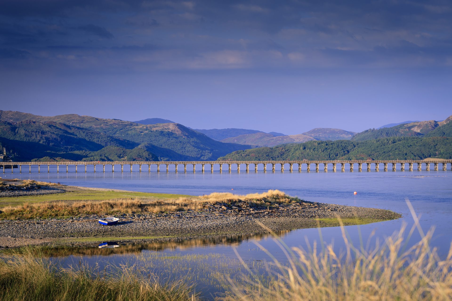
Mawddach Trail, Gwynedd, Wales
Sustrans calls the Mawddach Trail “one of the most scenic railway paths in the country”. And they’re not wrong. The trail runs for around 9 miles through the awe-inspiring Snowdonia National Park, offering jaw-dropping views as it goes. If you don’t want to travel the full length, the Snowdonia National park website recommends points to join the route at. It’s worth venturing along the whole route if you can though – the scenery is spectacular from beginning to end. You can travel the route in either direction, but it feels extra special if you travel from inland to the sea. Beginning in the market town of Dolgellau, you’ll go along the Mawddach Estuary, and finish at Barmouth, a pretty seaside resort. Look out for the imposing mountain, Cadair Idris, as you go along – it’s an ever-present backdrop to the trail. Luckily, there’s plenty of seating along the trail to stop and admire those views.
Explore the area with an OS map
Dennis Maps is one of the leading map printers in the world, producing more than two million maps and charts every year. We offer comprehensive pre-press services, large format print solutions using both large format litho printing and large format digital print technologies, plus specialised map folding and map finishing techniques.

Travel through time with the Great British History Map
We’re pleased to present the latest map hot off our presses – Strumpshaw, Tincleton & Giggleswick’s Intrepidly Time-Travelling Great British History Map. The newest map in ST&G’s Marvellous Maps series is a real blast from the past. It’s a full colour, two-sided map, packed with over 1,500 historical sites, trails and stories.
What’s on the map?

Its main feature is a beautifully illustrated map of Britain, filled with sacred spots, mysterious monuments, brutal battles, and much more. Key locations are explored in greater detail, so you can get to grips with the history of the area. Visit the ‘Stone of Destiny’ in Edinburgh, see where William the Conqueror won the Battle of Hastings, or cross the epic Menai Suspension Bridge to Anglesey. Areas of Outstanding Natural Beauty and National Parks are included on the map too, so you can bask in the beauty of the surrounding area after your historical tour.
Movers and shakers
Flip the map over to read about key movers and shakers from British history. Look out for famous faces (think Winston Churchill and Henry VIII), as well as figures who’ve been hidden in the shadows of history. Handily, the map links people to locations so you can visit the sites for a real-life history lesson. Venture to London’s St Thomas’s Hospital to see the first statue dedicated to a named Black woman – British-Jamaican nurse Mary Seacole. Or why not visit the Aneurin Bevan Memorial Stones? The monument, in Wales’s Ebbw Vale, is a celebration of the firebrand politician and architect of the NHS.
The ultimate historical road trip
On the reverse of the map there’s an illustrated guide to the top 50 historical sites in Britain, with a useful suggested travel route. From Shetland down to Cornwall, there’s plenty to keep you intrigued and entertained. The map features travel times to key locations, saving you legwork and making route planning that bit easier. There are even tick boxes so you can mark off sites as you go!

Festivals and events
This isn’t your standard list of festivals and events, it’s a round-up of all the weird, wonderful, and important historical events Britain has to offer. Party like it’s 1263 at the Largs Viking Festival, or celebrate the start of spring at the Lanark Whuppity Scoorie. You’ll be spoilt for choice, with over 50 events and festivals to choose from.
And that’s not all…
The Great British History Map is much more than just a map. It’s packed to the (medieval) rafters with extras. You’ll find timeless trivia to enjoy, including old nicknames for cities and random historical facts. There’s a guide to historical eras – also useful for the next pub quiz.
Peer carefully round the edge of the map and you’ll spot inspiring, funny, and insightful quotes from some of Britain’s greatest historical figures. A quote from Queen Victoria reads: “Give my people plenty of beer, good beer, and cheap beer, and you will have no revolution among them.” Wise words indeed! The map even has a spot to place your glass, so you can enjoy your drink of choice while planning your adventures. It’s interactive too, with links to entertaining images, videos and online content to fully immerse yourself in Britain’s fascinating history.
STG’s Great British History Map is available as a folded map – perfect for planning your adventures at home or on the road. There’s also the option to have a flat map or have it framed as a delightful addition to your house. Why not pick up your copy now and explore bygone Britain? We’re sure you’ll agree, it’s one of the greatest maps of all time.
Dennis Maps is one of the leading map printers in the world, producing more than two million maps and charts every year. We offer comprehensive pre-press services, large format print solutions using both large format litho printing and large format digital print technologies, plus specialised map folding and map finishing techniques.
The best UK picnic spots to try this summer
July is National Picnic Month, the perfect opportunity to eat al fresco. We’ve rounded up our selection of the UK’s best picnic spots, to help you plan where to visit this month or whenever the sun is shining.
Barafundle Bay, Pembrokeshire, Wales
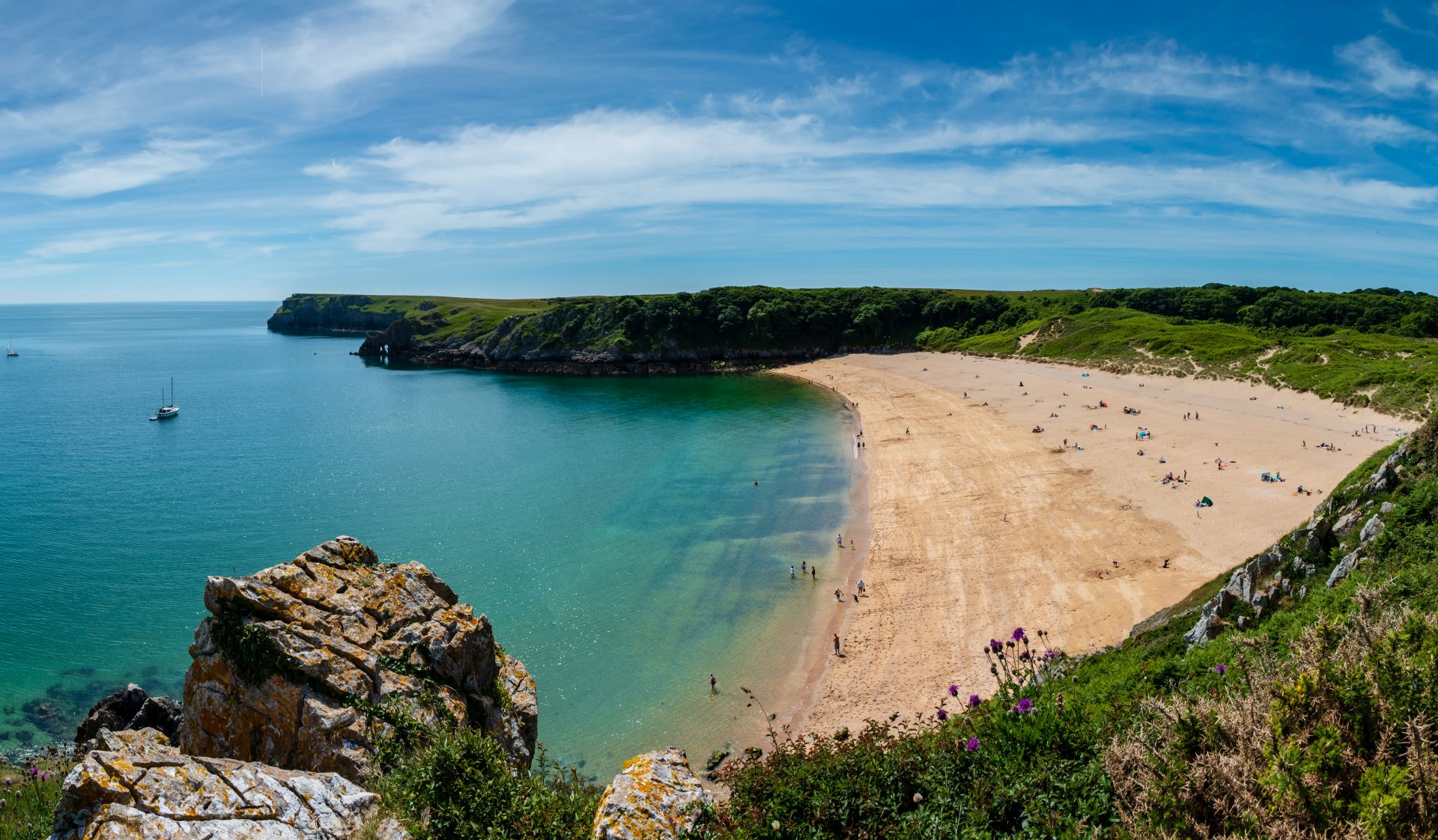
Barafundle Bay is renowned for its golden sands, gentle dunes, and azure waters. The small bay is reminiscent of a pristine, tropical beach – temperature aside. It’s even been awarded a Green Coast Award for being an unspoilt, hidden gem. Only accessible by foot, on a quiet day you really do feel like you’ve found your own private picnic spot. We’ve included Barafundle in our round-up of Britain’s 10 most beautiful beaches as well. Have a look if you want more inspiration for a picnic on the beach.
Find out more with an Ordnance Survey (OS) map of Pembrokeshire
The Fairy Pools, Isle of Skye, Scotland

We can’t promise you’ll spot any fairies, but this is certainly a magical spot. The Isle of Skye’s Fairy Pools are a series of crystal-clear rock pools filled by mountain waterfalls. Into wild swimming? The Fairy Pools are ideal for a dip pre-picnic. But be warned – they’re rather chilly! Bring your own snacks or drive via the Cuillin Coffee Co café for some cake and speciality coffee. Then sit back, relax and take in the dramatic views of the Black Cuillin mountains while you enjoy your picnic.
Discover the area with a map of Skye
Bowlees Picnic Area, Durham, England
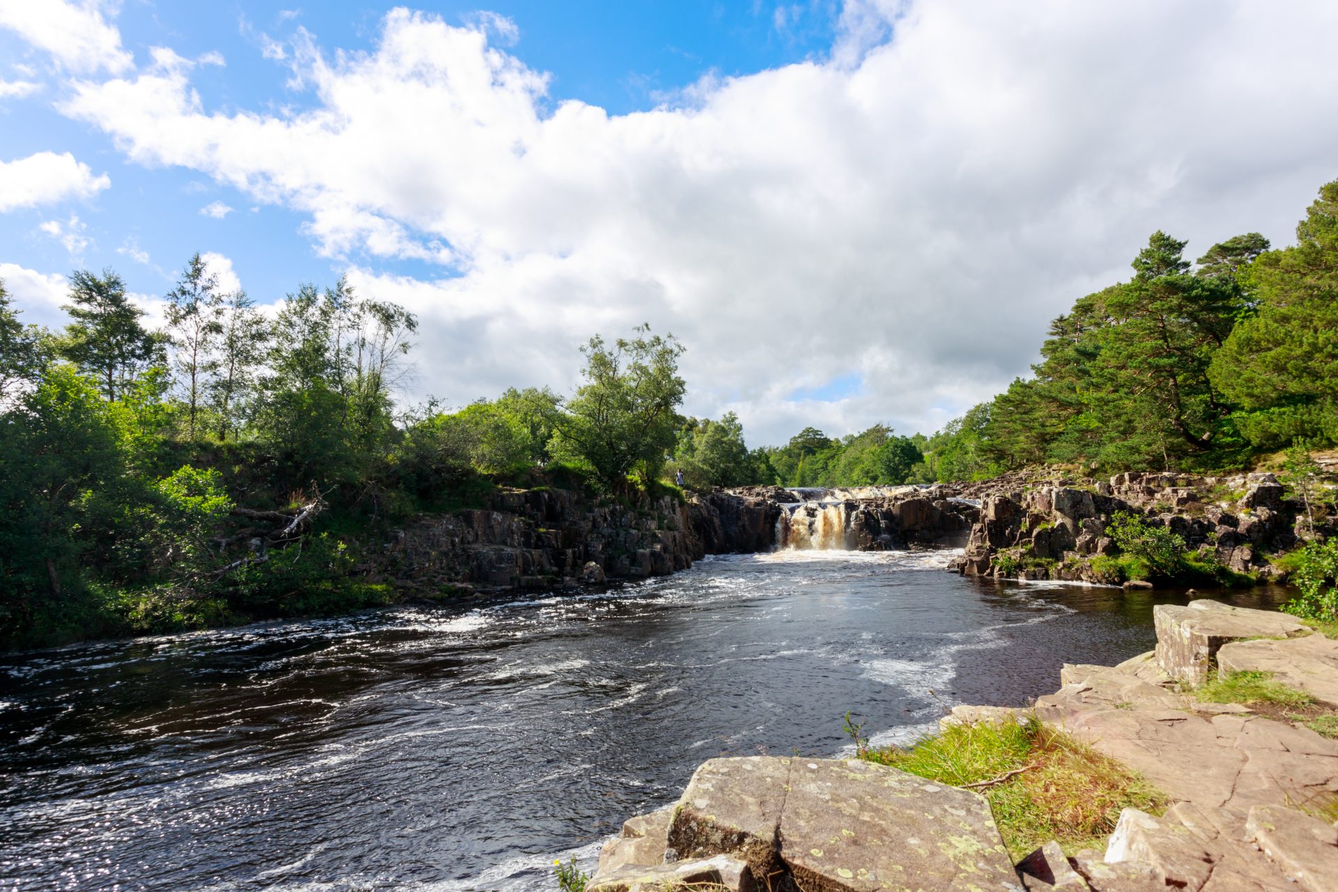
Bowlees Picnic Area is known for its famous neighbour – the spectacular High Force waterfall. High Force is around a two mile walk from the picnic site but definitely worth a visit. A towering 21 metres, you’ll hear it thundering before you first catch sight of the incredible waterfall. If you fancy a shorter stroll, there are four smaller waterfalls close to the picnic site. The picnic area itself is perfect for families – with a mud kitchen for little ones and a wildlife-friendly garden to explore. Bring your own food or stop by Bowlees Visitor Centre, to pick up some treats from the Falls Café.
Plan your visit with an OS map
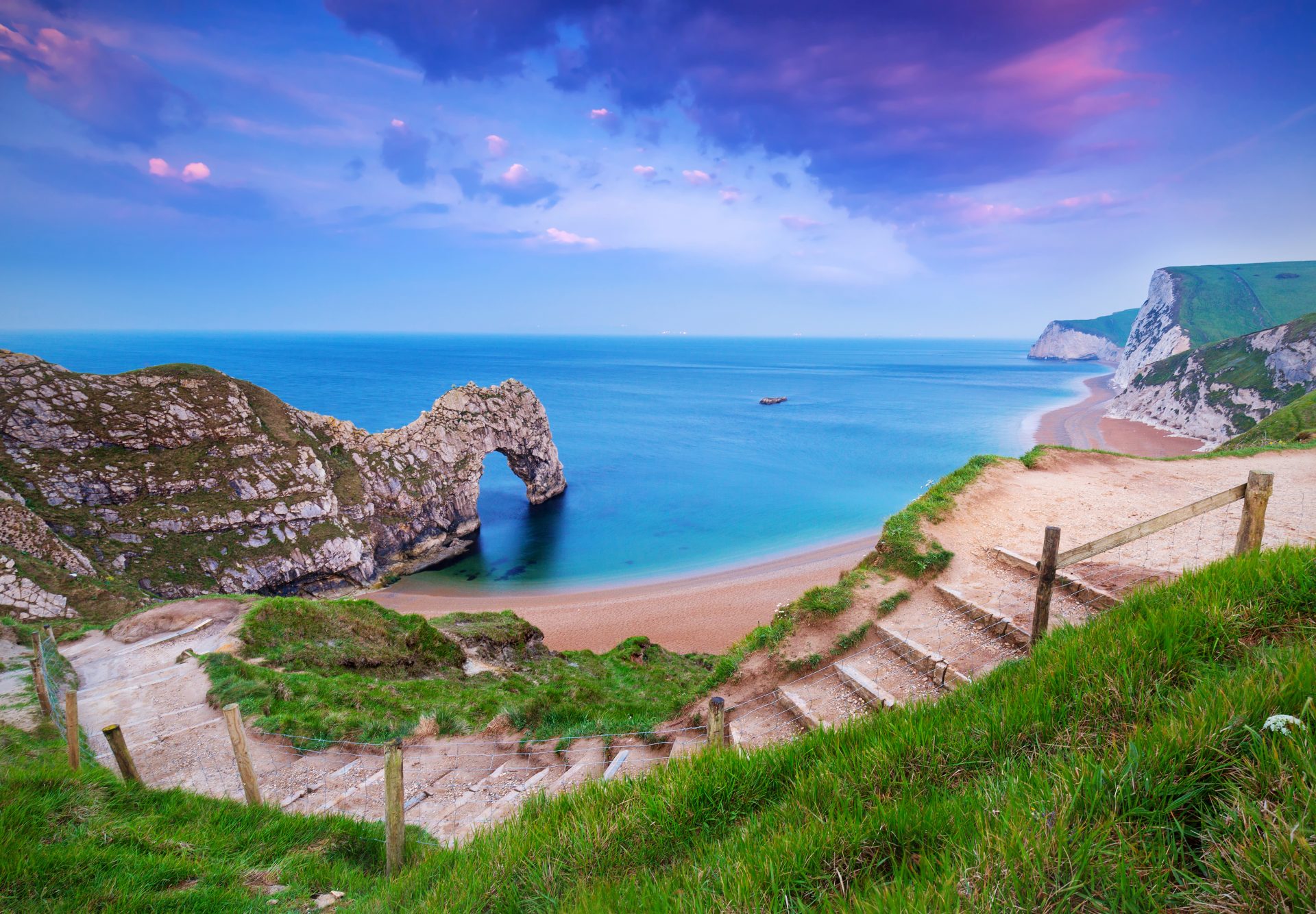
Durdle Door, Dorset, England
Durdle Door has been voted the UK’s most Instagrammable picnic spot, so don’t forget your selfie stick! It rates highly on Tripadvisor too, with one visitor calling it “simply stunning”. And we’re inclined to agree. Find a picnic spot on the beach for an excellent view of the limestone arch, a prehistoric relic, rising from the sea. Post-picnic why not explore the area? The Jurassic Coast is the country’s sole natural World Heritage Site – and an excellent spot for a fossil hunt.
Explore the area with a map of Purbeck and South Dorset
Castle Hill, Tenby, Wales

Castle Hill is an excellent spot for taking in all the town has to offer over a leisurely al fresco lunch. Lay your picnic blanket on the grass or relax on one of the benches dotting the area, as you breathe in the fresh sea air. Look out over the town’s pastel-coloured buildings, and boats bobbing in the harbour below. At one end of the peninsula there’s a Norman castle, now a ruin and an intriguing backdrop to your picnic. After lunch explore Tenby’s quaint cobbled streets, filled with shops, pubs and cafes.
Discover more with a map of Tenby
Dunstable Downs, Bedfordshire, England
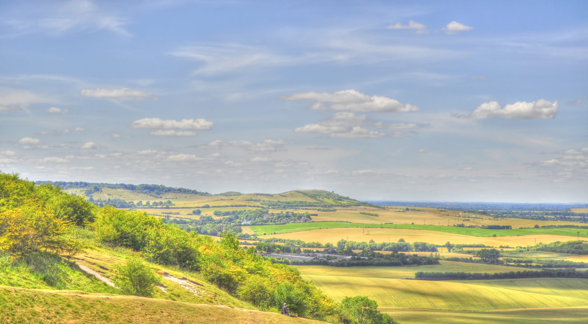
Dunstable Downs are famed as Bedfordshire’s highest location, with incredible views for miles around. We recommend having a picnic on a clear day, when the never-ending sky is at its most impressive. The view isn’t all you’ll marvel at though. Look up and you might spot red kite birds and an array of butterflies. Watch out for a rainbow of colourful kites dancing across the sky, too. The breezy Downs are popular for kite flying. If you fancy stretching your legs after lunch, there’s a network of walking trails across the area. The National Trust has a handy guide to some of the routes.
Pick up an OS map for your day trip
Royal Botanic Garden Edinburgh, Scotland

Visit Scotland calls the Royal Botanic Garden Edinburgh “one of the finest botanic gardens in the world”. The garden may be in the city, but it’ll transport you from the hustle and bustle to a peaceful oasis of plants. With several themed sections, there’s lots to see. Check out the Biodiversity Garden, described by the Botanic Garden as having hundreds of plants displayed in their evolutionary order. With more than 70 acres to explore, you’ll be spoilt for choice when choosing a picnic spot, too.
Use an OS map to plan your trip.
Read next Britain’s 10 most beautiful beaches and Five Awe Inspiring UK Forests
Dennis Maps is one of the leading map printers in the world, producing more than two million maps and charts every year. We offer comprehensive pre-press services, large format print solutions using both large format litho printing and large format digital print technologies, plus specialised map folding and map finishing techniques.

Five top tips for printing a map
You’ve spent a lot of time and effort designing a map and now you’re at the exciting stage where it’s ready to be printed. So, what should you consider when it comes to printing your custom map? Here are five useful tips to guide you through the map printing process.

Size matters
If possible, send your file at the size you’d like it to be printed. Smaller size documents can be enlarged but in most file formats this reduces the resolution. This means that text and images may look less crisp and clear. Printing a larger file isn’t a problem though. Reducing a file size increases the resolution, so won’t have any impact on the quality of the text and images on your map.
Where will the folds fall?
When designing your map think about where the folds in the material will fall. Text and images can be harder to read and see if they are on a fold. For example, it’s better to have your map key away from a fold. If you have columns of text, have the folds on the gaps between the columns, so you’re not reading over a fold.
Choose your paper carefully
Think carefully about how your map will be used. Will it be used outdoors? Indoors? In poor weather conditions? At Dennis Maps we offer a variety of materials for your map to be printed on. You can choose from two varieties of synthetic, waterproof paper. These papers are rip proof and weather resistant, so perfect for British weather! Alternatively, we have coated and uncoated papers, both of which are lower down the price point and can be recycled more readily. Ink sits on the surface of coated paper, adding an attractive vibrancy to your finished map. Ink soaks into uncoated paper a little more, which gives less glare when a map is used in sunny conditions.

Do you need a bleed?
In most cases, you’ll need a 3mm bleed on your map when you send it to be printed. A bleed is the printed part of a document that extends outside the area where it will be trimmed to size. The bleed preserves detail if the cutting device used to trim your map goes slightly within the edges of a document. Without a bleed you might be left with an unwanted white line. However, you only need a bleed if the images or text on a map go right up to the edges of the document.
Consider your colours
Make sure any map you want printed is in CYMK rather than RGB. CYMK is the format used for printed documents, while RGB is optimum for documents online. The latter has a much larger range of colours which look as they should on screen but may not convert well to a printed document and CYMK. It’s also worth checking if text that appears black is actually black. Sometimes text can look black but be made up of several colours, so will not appear black when printed.

We hope these tips have been helpful. Please get in touch if you have any questions about map printing or our services. At Dennis Maps, we’re on hand to offer advice at every stage of the map printing process. We specialise in large format printing, if you want to print large get in touch!
Read more about map finishing.
Dennis Maps is one of the leading map printers in the world, producing more than two million maps and charts every year. We offer comprehensive pre-press services, print custom maps and large format print solutions using both large format litho printing and large format digital print technologies, plus specialised map folding and map finishing techniques.
Britain’s 10 most beautiful beaches
It’s the perfect time to plan a visit to the British coast, with many of us choosing staycations and day trips this summer. Luckily, you don’t have to venture far to find stunning beaches to explore, whatever the weather. We’ve rounded up Britain’s 10 most beautiful beaches to give you plenty of ideas. Now all you have to do is find your bucket and spade.
1. Rhossili Bay, Glamorgan, Wales
Useful info: Dog friendly
Rhossili Bay has been named one of the world’s best beaches, alongside some absolute stunners, in locations like Thailand, Hawaii and Brazil. And we can see why. The Bay is a spectacular golden curve of sand on the edge of the Gower Peninsula, an Area of Outstanding Natural Beauty. Most summers, fields behind the beach are blanketed with thousands of sunflowers, adding to the incredible view.
Explore the area with a map of the Gower Peninsula
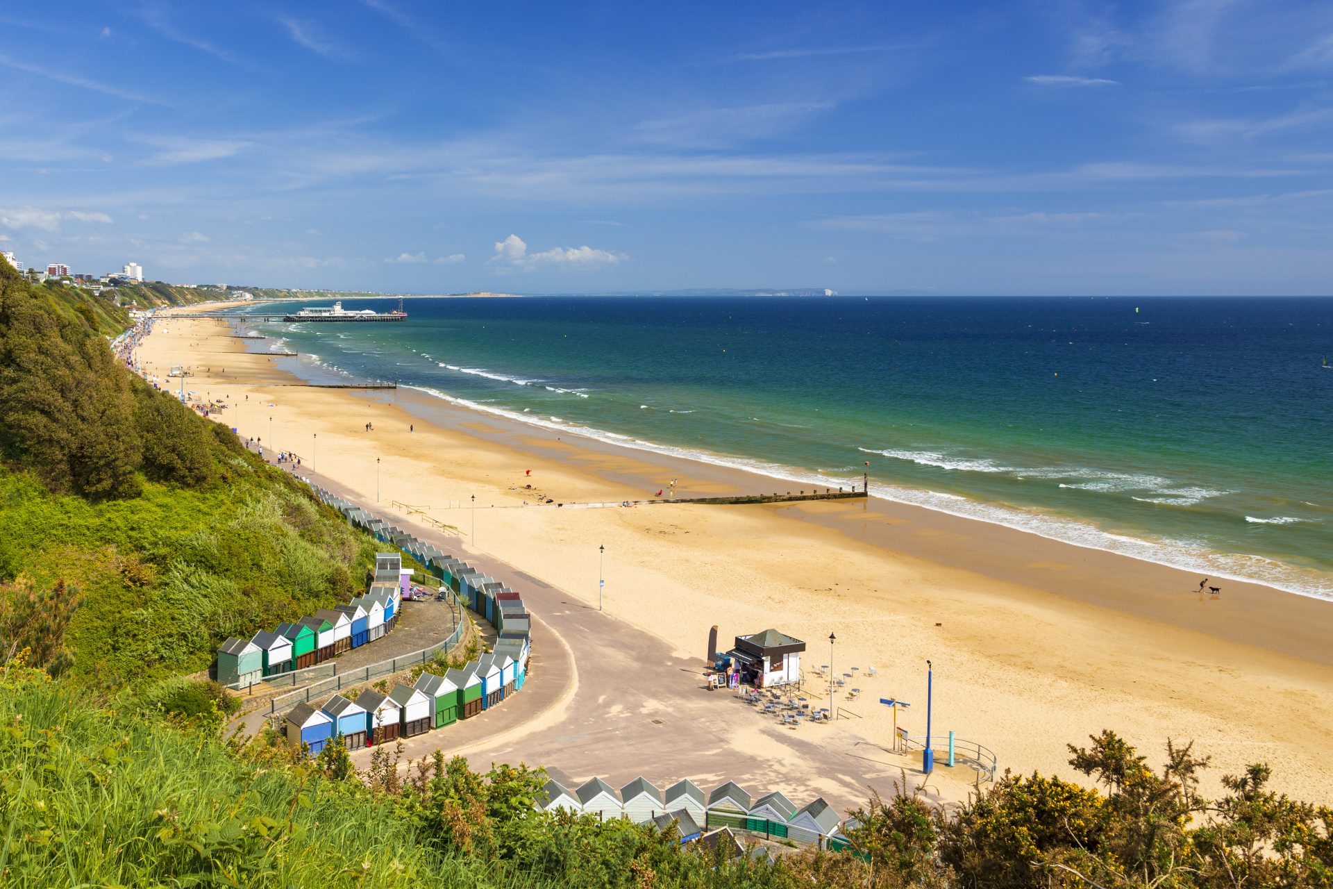
2. Bournemouth Beach, Dorset, England
Useful info: Lifeguards in season, dog friendly (with restrictions), accessible
Bournemouth Beach is the location for you if you’re after a buzzy feel to your beach trip. Its sandy shores have plenty of water sports on offer and a Victorian pier to explore, featuring its own zip wire and amusements. If you fancy a swim, it’s the perfect spot too, with the warm water benefitting from its own microclimate. The beach itself was named the UK’s best in the 2019 TripAdvisor Travellers’ Choice Awards.
Use an Ordnance Survey (OS) map to plan your visit
3. Sandwood Bay, Sutherland, Scotland
Useful info: Dog friendly (with restrictions)
Visit Scotland says Sandwood Bay is considered “one of the most unspoilt beaches in the whole of mainland Britain”. The beach, near Cape Wrath in north-west Scotland, can only be reached by a four-mile-long footpath, but it’s worth the effort. You’ll find a glorious stretch of sand backed by sand dunes, cliffs and Sandwood Loch. From the beach you’ll also see the Am Buachaille sea stack majestically rising from the wild Atlantic. In times gone by, there were claims of mermaids emerging from the water, another sight to look out for!
Plan your visit to the area with an Ordnance Survey (OS) map
4. Woolacombe Beach, Devon, England
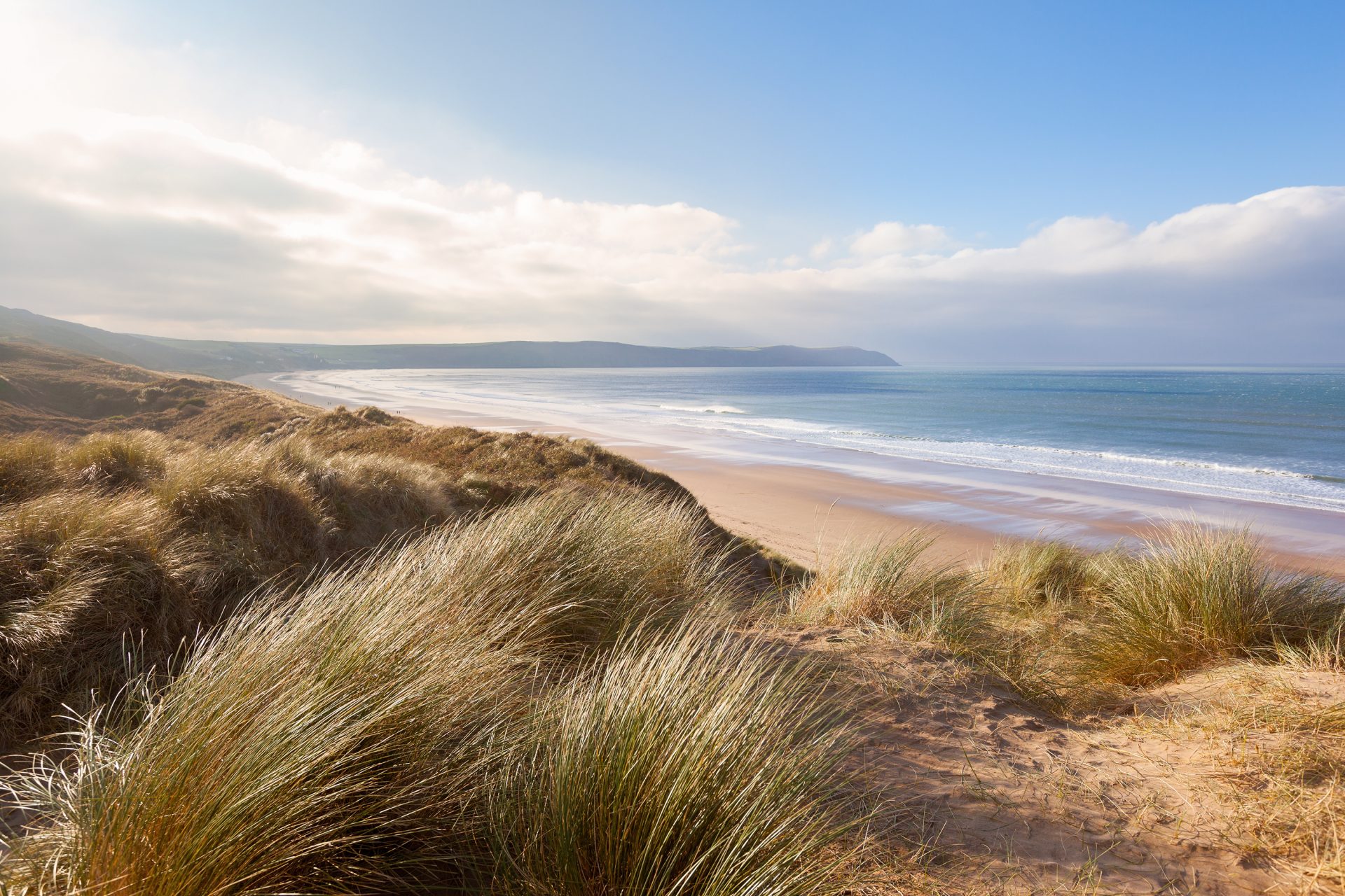
Useful info: Lifeguards in season, some accessibility, dog friendly (with restrictions)
You’ll need your bucket and spade when visiting the three miles of golden sand at Woolacombe – the perfect spot for sandcastle building. The north Devon beach has an air of tradition about it, with pretty, colourful beach huts lining some of the sand. Surfers are attracted here by its powerful Atlantic waves. It’s right by the South West Coast Path too, so is a great spot for walkers.
Plan your visit with an OS map
5. Luskentyre Sands, Harris, Scotland
Useful info: No lifeguards
You could be forgiven for thinking you’ve stepped onto a Caribbean beach when you visit Luskentyre Sands – weather aside! The beach, on the Isle of Harris, is an expanse of pure white sand and crystal-clear waters. Standing on the spectacular beach, you can see Harris’ towering mountains, as well as nearby Taransay Island, the location of the BBC series Castaway 2000. If you’re lucky you might also spot wild ponies among the sand dunes.
Find out more with an OS map of South Harris
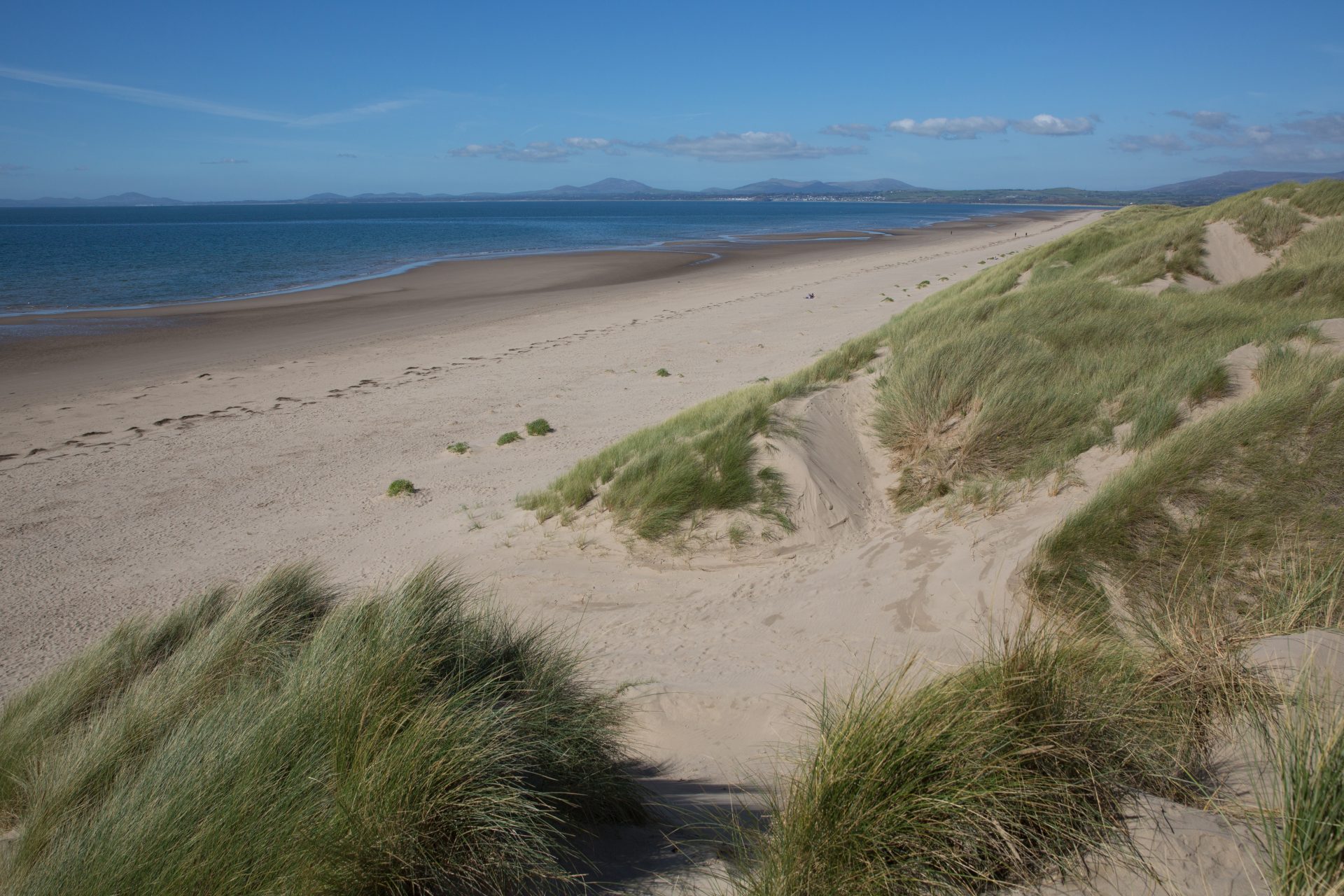
6. Barafundle Bay, Pembrokeshire, Wales
Useful info: Dog friendly
This remote, sandy beach merges into sand dunes and lush woodland as you move inland, making for an excellent view. It has a Green Coast Award for being an unspoilt, hidden gem and it’s certainly deserving of the accolade. There are no facilities on the beach, but you can find a bathroom and café at the nearest car park. You might want to bring your own food and refreshments anyway. The beach was once named the best UK spot for a picnic by Country Life magazine.
Find a map of Barafundle Bay
7. Porthcurno Beach, Cornwall, England
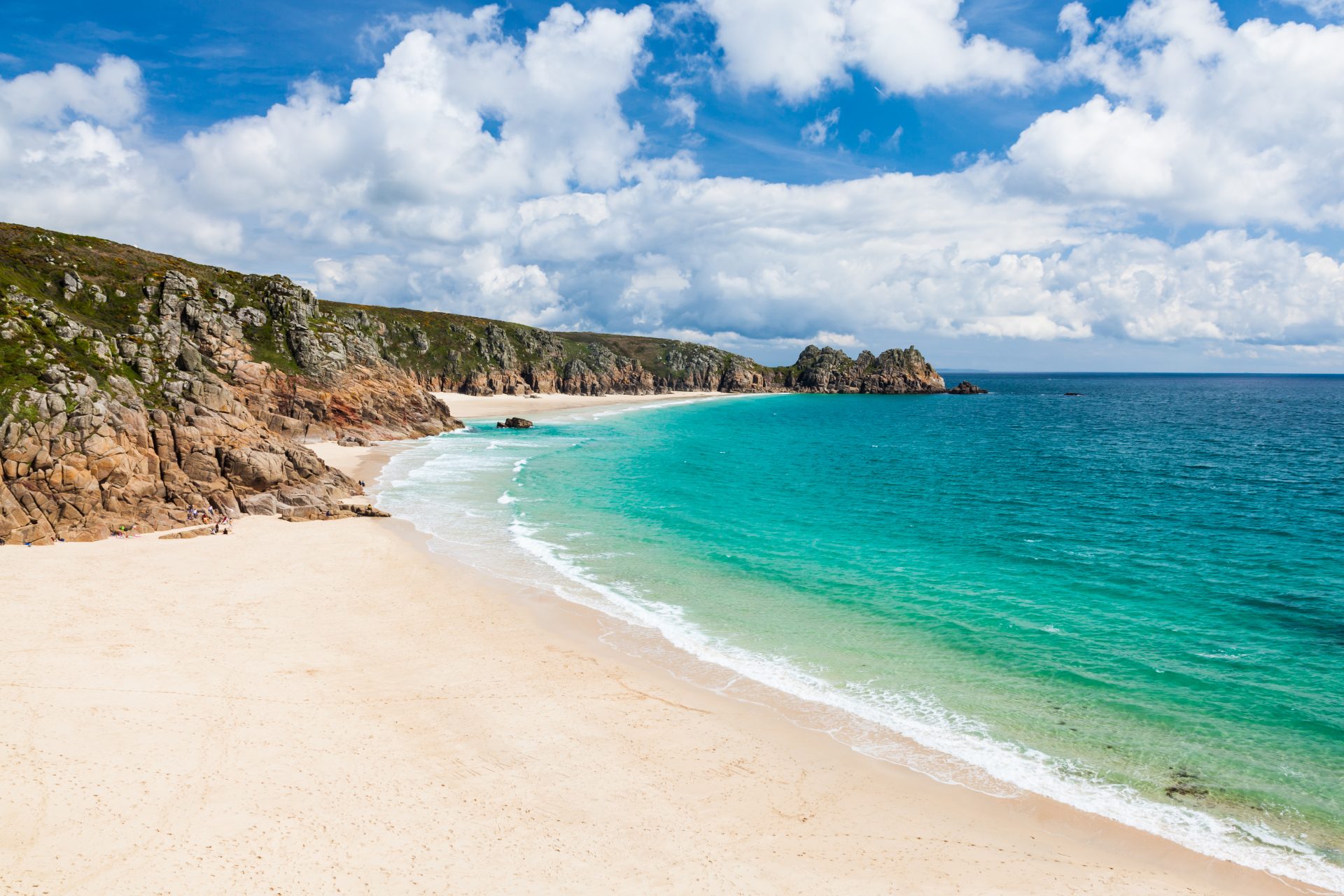
Useful info: Dog friendly (with restrictions), lifeguards in season
Porthcurno Beach is a stunning white shell beach sheltered by high granite cliffs. On one of these cliffs stands the Minack Theatre, a unique spot to enjoy an open-air play. Look out for Treen Castle, a clifftop fortress, too. Poldark fans may recognise the beach as the iconic Nampara Cove. Scenes from the popular show were shot at Porthcurno.
Discover more about the area with a custom OS map
8. West Sands Beach, Fife, Scotland
Useful info: Dog friendly (with restrictions), lifeguards in season, accessible
Head to West Sands Beach in St Andrews for a seaside trip with an urban feel. It’s a short walk from the town centre and you can see the historic settlement from the sand. There are lots of activities on offer if you want a shot of adrenaline injected into your trip. Think land yachting, surfing and kayaking. Of course, you may prefer a gentle stroll along its two miles of golden sand, made famous in the opening sequence of Chariots of Fire.
Use an OS map to arrange your visit
9. Harlech Beach, Gwynedd, Wales
Useful info: Dog friendly (with restrictions)
Wherever you stand on Harlech’s golden sands there’s something incredible to see. The beach lies within Snowdonia National Park and has fine views of its many peaks. Harlech is unique for the growing system of sand dunes rising from the landscape. Look out for leatherback turtles in the summer, too. They’re often spotted feeding in the blue waters.
Pick up an OS map to explore the area
10. Bamburgh Beach, Northumberland, England
Useful info: Dog friendly
Bamburgh is a beach where history swirls enticingly round you on its windswept coast. The past feels ever present as you gaze at the imposing castle rising up behind the beach, or out across the water to the Farne Islands and Lindisfarne. The unspoilt beach is ideal for a blustery walk, where you can get back to basics and enjoy the landscape.
Plan your trip with an OS map of Holy Island & Bamburgh